


Rising sea levels will amplify the flood risk in coastal cities like Miami, New York, Rotterdam and Guangzhou, while population increase and economic growth will increase the value of the assets at risk to new levels By Celine Herweijer and others
Understanding future coastal flood risk requires a multi-disciplinary approach, combining expertise across climate science, catastrophe modelling, economics and policy. In 2007, the Organization for Economic Co-operation and Development (OECD) brought together a team involving Risk Management Solutions (RMS), the University of Southampton/Tyndall Centre for Climate Change Research and CIRED/Meteo- France.
The result, published in the report Ranking Port Cities with High Exposure and Vulnerability to Climate Extremes: Exposure Estimates, was the most geographically extensive study on urban coastal flood exposure ever undertaken. It ranked 130 key port cities worldwide by exposure to coastal flood both today and as projected for the 2070s. A key objective was to identify the hotspots (or accumulations) of human and economic coastal flood exposure today and in the future, and thus pinpoint places in which investment in adequate flood defences, resilience and disaster preparedness is, and will become, most critical.
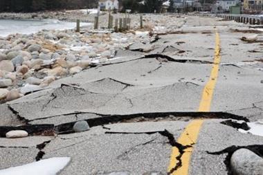
The city rankings reflect today’s coastal flood exposure, and projected 2070s exposure given the likely impact of climate change (sea level rise and a change in storminess), natural and human induced land subsidence, population growth and urban economic growth. The exposure measure represents the population or assets exposed to a 1-in-100 year surge event now and in the future, rather than the risk of coastal flooding. In other words, the measure represents the population/assets reliant on adequate and well maintained flood defences, in this case to the minimum 1-in-100 year standard. As the example of Hurricane Katrina in 2005 painfully highlights, flood protection does not eliminate risk and so exposure represents an important measure for (re)insurance industry, as well as policymakers.
The OECD study demonstrates that as many as 150 million people in large port cities could be reliant on flood defences by 2070 – more than three times current numbers – as a result of climate change, subsidence and urban development. Asset exposure is projected to grow even more rapidly to $35 trillion in the 2070s, more than 10 times current levels and representative of 9% of projected global GDP.
In terms of underlying drivers of this increase, climate change and subsidence contribute approximately a third of the increase in exposure, with socio-economic growth accounting for two-thirds. This statistic brings home the crucial message that, without action today to ensure sustainable development, economic growth itself will strongly aggravate the impacts of climate change on coastal flood exposure.
Rising sea levels
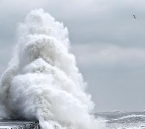
In 2007, the Intergovernmental Panel on Climate Change (IPCC) report laid out an array of climate projections for the coming decades. Of these, two were portrayed with greatest certainty – the earth will continue to warm due to an increase in greenhouse gas emissions and, as a result, sea levels will carry on rising. While we cannot be sure of the rate of sea level rise - 0.5m, 1m or 1.5m by the end of this century - we do know that to date observations show it is already rising faster than our climate models predict.
Traditional catastrophe risk management focuses on storm surges as a cause of flood, rather than sea level rise as such. Hurricane Katrina’s impact on New Orleans reminds us how devastating an impact a surge can be on a region without adequate defences. Future sea level rise will elevate the height of surges. Combined with the possibility of more intense storms (see box opposite), this means that, coastal flood exposures will rise. Coastal flood maps will have to be re-drawn, and defences upgraded. Managing the risks associated with rising coastal flood hazard will increasingly become a priority issue for coastal communities, businesses and insurers.
A closer look at US cities Today, the United States is home to five of the top 10 global cities in terms of assets exposed to coastal flooding identified in the study: Miami (1), Greater New York (2), New Orleans (3), Tampa-St Petersburg, FL (9) and Virginia Beach, VA (10).
By the 2070s, the value of assets exposed in key US port cities is projected to rise to over $9 trillion, representing some 15% of projected US GDP. Miami remains at the top of the 2070 rankings, with exposed assets increasing from approximately $400 billion today to over $3.5 trillion (Figure 1).
Greater New York ranks third, with assets exposed to a 1-in-100 year flood rising to over $2.1 trillion by the 2070s. Regulations in New York City require that planners adopt the relevant measures and building codes to protect against a 1-in- 100 year flood. This standard is much lower than cities of comparative wealth, such as London and Tokyo, which are protected to a 1-in-1,000 year flood – which is surprising given the city’s huge exposure. Furthermore, the Federal Emergency Management Agency (FEMA) flood insurance rates maps for New York City are recognised as significantly out of date, indicating that existing building stock will not be adequately protected in some regions.
Approximately one-quarter of the projected growth in assets exposed to a 1-in-100 year flood in Greater New York can be apportioned to climate change and natural subsidence, and three-quarters to socio-economic growth. This statistic highlights two key messages for New York City, which can be applied more widely.
First, it is critical that cities maintain accurate flood maps and protection measures that keep pace with rising surge hazard, given future climate change. Second, cities must grow in a risk-averse fashion: new infrastructure (buildings and defences) must be concentrated away from the flood plains or built with protective measures that will be appropriate over the lifetime of the building. New York has begun to address these issues. In April 2007, the New York City government released a comprehensive sustainability plan, PlaNYC, which includes a handful of projects focused on adapting the city to climate change.
These initiatives include updating the FEMA flood maps and amending building codes to address climate change. Today, New York City is far ahead of its peers on adaptation to climate change. For example, Miami, ranked first globally in the OECD study, currently has no public adaptation plan.
Increasing exposure
Due to the rapid economic expansion expected in developing world cities, the highest asset exposure is projected to become more concentrated in Asian cities, with eight of the top 10 situated in this region: Guangzhou, Kolkata (Calcutta), Shanghai, Mumbai, Tianjin, Tokyo, Hong Kong and Bangkok. Seventeen out of the 20 cities with the largest proportional increase in asset exposure by the 2070s are located in Asia. They comprise both mega-cities and current second-tier cities.
For these fast growing cities, much of the increase in flood risk can be mitigated at low cost through risk-based development planning. The strong message for local policymakers is that they have a real opportunity to avoid future catastrophes and economic setbacks by implementing adaptation strategies early.
In many Asian communities, human-induced subsidence due to shallow ground-water extraction and drainage can significantly aggravate future flood exposure. This is particularly important in rapidly developing delta cities, such as Ningbo and Wenzhou in China and Jakarta, Indonesia. Again, through taking action to manage the processes that cause humaninduced subsidence today, significant reductions in future exposure (50% - 25% for these examples) can be realised.
As businesses and insurers expand their operations in Asia, these numbers clearly highlight that public and private investment in adaptation will be critical to sustaining long term financial stability. Insurers can play an important role in these regions through engaging with policymakers to communicate the risks.
The benefits of adaptation
The adaptation messages of the OECD report are clear: projected asset exposure in the 2070s can be reduced by 90%, and population exposure by 60%, by managing development away from high-risk areas, and by building and maintaining city defences to at least a 1-in-100 year standard with sea level rise. Given the large future exposure of port cities to coastal flooding ($35 trillion), the argument for investment in proactive and risk-informed adaptation is resounding.
The success (or lack) of adaptation measures will have a direct effect on pricing and availability of insurance. The OECD study demonstrates that successful adaptation can lead to significant reductions in coastal flood risk, which will help to maintain insurability in these highly exposed regions. For the insurance industry, there is both a necessity and an opportunity to promote and lead on adaptation through engaging with both policymakers and policyholders. Rising sea levels are one effect of humandriven climate change that will bear upon our coastlines without discrimination, but it is one to which we have considerable capacity to adapt.
We can reduce the future costs of climate change by taking action to reduce greenhouse gas emissions, and this must also continue to be a major global focus. Greenhouse gas mitigation, however, will slow the effects of climate change over the coming century, not prevent or reverse them. At the very least, mitigation will buy precious time to implement the necessary adaptation to protect us from the effects of climate change impacts to which we are already inevitable.
Impact of Climate Change
As our planet warms on the heels of rising levels of atmospheric greenhouse gases, our oceans heat and expand, and our glaciers and ice sheets melt, raising global sea levels and elevating the base height of storm surges around the world. Even if windstorm strength remains unchanged, this would cause a rise in coastal flood hazard. In reality, of course, climate change also impacts the nature of tropical and extra-tropical windstorms that drive storm surges.
Climate models suggest that in some regions we may expect more intense tropical and extratropical windstorms, which will magnify the impact of sea level rise on surge height. This link is complex, however, as many competing factors influence the intensity, frequency and geography of change in tropical or extratropical storms.
Nevertheless, a simple stress test experiment with a catastrophe risk model can demonstrate that over the coming decades the effect of projected sea level rise on surge-related losses to coastal property will predominate over the impact of projected changes in, for example, hurricane activity. In other words, even in the case where climate change gives rise to lower hurricane activity several decades from today, the impact of rising sea levels still causes coastal flood hazard to increase. The implication for policymakers, planners and insurers alike is that coastal flood hazard is on the rise, and that flood risk management strategies will need to keep pace with this change to prevent risk from escalating.
Postscript
Celine Herweije is director of the climate change practice at Risk Management Solutions. She was one of the authors of the OECD report. celine.herweijer@rms.com www.rms.com.


No comments yet