


With estimated losses of between US$2.5 billion and US$4.5 billion, Strategic Risk examines the key lessons from Hurricane Otis and key steps for affected businesses
Hurricane Otis was an unprecedented event across multiple fronts.
As a Category 5 storm with 165 miles per hour sustained winds, it was the strongest landfalling hurricane on record in both the Acapulco region and Mexico as a whole, aided by a period of record rapid intensification in the 24 hours prior to landfall.
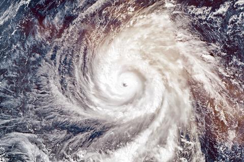
Because the storm intensified so quickly, with wind speeds increasing by 115 mph within 24 hours, the more than one million people living in and around the city had very little time to prepare for the monster storm ahead of landfall.
Only one other storm on record, Hurricane Patricia in 2015, exceeded Otis’ rapid intensification in the Eastern Pacific, with a 120-mph increase in 24 hours.
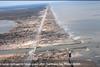
The NOAA said: ”Reports and images from Acapulco showed catastrophic damage to structures, including many hotels and high-rise buildings, as well as downed trees, severe flooding, and mudslides. Damage was also reported at 120 hospitals and clinics.
”Additionally, more than 10,000 utility poles were destroyed, knocking out power and internet/communications across the region, while numerous transmission lines, electrical substations, and a power plant were also heavily damaged.”
Insured losses from Hurricane Otis are estimated to be between US$2.5 billion and US$4.5 billion, according to Moody’s RMS.
The hurricane caused damage to a large stretch of modern, high-rise exposure along Acapulco Bay, including apartment complexes, hotels, and resorts.vLosses will be largely driven by wind damage with a minor contribution from storm surge and precipitation-induced flooding, the modeller said.
Moody’s says that Aerial imagery and reconnaissance show that Otis caused some of the most incredible wind damage to modern-day high-rise structures ever seen. It adds that observed winds well-exceeded prevalent design wind speeds for the region.
How Hurricane Otis unfolded
Hurricane Otis was the fifteenth named storm of the 2023 Pacific hurricane season, the tenth hurricane, and the eighth major hurricane. Otis was the first Category 5 hurricane to make landfall on the west coast of Mexico since recordkeeping began.
After undergoing an unexpected period of rapid intensification in the 24 hours prior to landfall, in which the storm intensified by more than 110 miles per hour (175 kilometers per hour), Otis made landfall on Wednesday, October 25, 2023, near Acapulco, Guerrero as a Category 5 hurricane on the Saffir-Simpson Hurricane Wind Scale.
At landfall, Otis had maximum sustained winds of 165 miles per hour (270 kilometers per hour). The storm brought hurricane-force winds to coastal and inland portions of Guerrero and a small portion of Michoacán.
Storm surge, heavy rainfall, and associated flooding were also reported to have impacted southwestern Mexico.Less than one month remains in the 2023 Pacific hurricane season, which officially ends on November 30.
Credits: NOAA NASA CIRA Music: “Dark Mist” by Benson Taylor [PRS]; A Remarkable Idea; Universal Production Music
What can businesses learn from the event
Lack of modelling data and underinsurance are two key lessons from Hurricane Otis.
Julie Serakos, senior vice president, Moody’s RMS, explained: “In determining the overall damage estimates from this event, underinsurance is a common theme. Much of the damaged exposure is unlikely to be insured to the full value of the structure or insured at lower limits, especially in inland regions.”
“We expect most of the insured losses to be driven by damage to coastal commercial and commercial residential exposure. Nevertheless, we expect Otis to be one of the costliest hurricanes in Mexico’s history from both an economic and insured loss perspective.”
Jeff Waters, staff product manager, North Atlantic hurricane models, Moody’s RMS, added: “Observational windspeed data – while limited – suggests a broad swath of exposure and population was affected by major hurricane-level wind gusts.
Understanding the loss estimates
Insured losses from Otis will be driven by wind damage with a minor contribution from storm surge and precipitation-induced flooding. Insured wind losses include commercial multi-family dwellings, hotels, resorts, and high-rise buildings that have been severely affected by this event.
The estimate reflects property damage and business interruption losses to residential, commercial, industrial, and automobile lines of business, and considers the potential for post-event loss amplification (PLA), inflationary trends, and non-modeled sources of loss, including infrastructure damage.
The estimate does not include losses for any sovereign protection programs (i.e. Mexico’s FONDEN) as a result of this event, which includes both traditional (re)insurance and insurance-linked securities.
Moody’s RMS industry loss estimates for landfalling hurricanes provide a comprehensive view, reflecting modeled and non-modeled impacts from all major drivers of damage, including wind, storm surge, and inland flooding.
”Prior to Otis, this region of Mexico had never experienced a Category 5 hurricane landfall, underscoring the importance of using catastrophe models to fill in gaps associated with the historical record, understand the events that haven’t happened yet but could, and the potential impacts on present-day exposure at-risk.”
While several tall buildings survived record gusts, thanks to well-designed structural systems in place for earthquake safety, their lightweight cladding and exterior that improves seismic performance, bore the brunt of high winds and were destroyed.
Rajkiran Vojjala, vice president, model development, Moody’s RMS, commented: ”Recovery and reconstruction efforts could take years. During this time, we expect a high number of total constructive losses given the damage severity and complexity of repairs.”
Hurricane Hazards
The NOAA explains the greatest hazards caused by hurricanes
While hurricanes pose the greatest threat to life and property, tropical storms and depression also can be devastating. The primary hazards from tropical cyclones (which include tropical depressions, tropical storms, and hurricanes) are storm surge flooding, inland flooding from heavy rains, destructive winds, tornadoes, and high surf and rip currents.
- Storm surge is the abnormal rise of water generated by a storm’s winds. This hazard is historically the leading cause of hurricane related deaths in the United States. Storm surge and large battering waves can result in large loss of life and cause massive destruction along the coast.
- Storm surge can travel several miles inland, especially along bays, rivers, and estuaries.
- Flooding from heavy rains is the second leading cause of fatalities from landfalling tropical cyclones. Widespread torrential rains associated with these storms often cause flooding hundreds of miles inland. This flooding can persist for several days after a storm has dissipated.
- Winds from a hurricane can destroy buildings and manufactured homes. Signs, roofing material, and other items left outside can become flying missiles during hurricanes.
- Tornadoes can accompany landfalling tropical cyclones. These tornadoes typically occur in rain bands well away from the center of the storm.
- Dangerous waves produced by a tropical cyclone’s strong winds can pose a significant hazard to coastal residents and mariners. These waves can cause deadly rip currents, significant beach erosion, and damage to structures along the coastline, even when the storm is more than a 1,000 miles offshore.
What businesses should do after a hurricane
Recovery
- Cordon off areas where power lines are down to prevent injuries. Coordinate repairs with the local utility. Prioritize power restoration for critical locations/operations.
- Check for leaking natural gas, propane gas, or gasoline from storage tanks or vehicles.
- Identify and control potential ignition sources if flammable liquids or combustible gases are present.
- Work with salvage crews to prioritize items that require immediate attention above those less susceptible to damage if left for a day or two. Quickly remove standing water and debris, clean and dry vital equipment, and dehumidify damp areas.
- Check and replenish hurricane protection supplies.
- Isolate damaged areas and evaluate, prioritize and expedite necessary structural repairs to minimize business interruption exposure. Provide temporary covers for windows, wall openings and roofs that have been damaged. “Laydown” areas, for the accumulation of combustible debris, should be designated away from any significant buildings or structures.
- Return fire protection systems (water supplies, suppression systems, alarm and detection systems, etc.) back into service as quickly as possible.
- Suspend cutting, welding and other hot work operations until fire protection systems are returned to service.
Should a loss occur, remember to document everything
- Take photographs of all damage and areas where your site is impacted.
- Develop a claim timeline with milestones for your team and the insurance adjustment team to manage expectations on both sides of a claim.
- Capture all invoices, contracts, etc., for loss-related work, including detailed descriptions of the temporary and/or permanent repair/replacement work to be performed.
- Ensure that all loss-related incurred costs are classified and categorized in real-time per your “bucket” of insurance coverages and by loss area/component, such as location, individual equipment, structures, and contents.
- Track – with detailed descriptions describing loss related activity – all in-house costs, such as hourly labor time and cost [with fringes] per person, salaried labor time and cost per person, in-house parts/materials consumed, expenses incurred, time sheets, expense reports, etc.


No comments yet