


Case study: How radar satellite data transformed crisis response after Hurricane Melissa
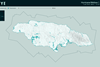
When Hurricane Melissa struck Jamaica as a Category 5 storm, satellite-based synthetic aperture radar provided near real-time, countrywide damage intelligence through cloud cover, enabling government and humanitarian teams to prioritise resources, accelerate decision-making and reach the hardest-hit communities faster.
For continued access to free content, you need to register. (If you’re already registered, please sign in here.)
REGISTER NOW FOR FREE
We’re glad you’ve chosen StrategicRISK as your essential source for risk management insight and hope you’ve been enjoying our content.
Gain access to our full archive of flagship quarterly digital issues, packed with strategic insights, market commentary, and opinion from leading risk management professionals. Registering is quick, easy, free, and will also have the additional benefits:
- Uncover Critical Insights: Dive deep with exclusive annual reports, fuelled by expert analysis on topics like climate change and industry trends.
- Stay Ahead with Expert Analysis: Award-winning coverage and analysis, delivered directly to your inbox through our newsletters.
- Curate Your Knowledge: Build a personalised library of essential articles and reports for quick reference.
- Access Premium Content: Unlock our full archive of in-depth articles, case studies, and expert opinions.
We also offer a dedicated print subscription.
LEARN MORE


- Forgotten Password
- Contributors
- Feedback
- Media Pack
- © StrategicRISK 2026
Part of the Insurance and Risk group of
Newsquest Specialist Media
Newsquest Specialist Media


Published by Newsquest Media Group Limited,
registered in England & Wales with number 01676637
at The Echo Building, 18 Albert Road, Bournemouth,
England, BH1 1BZ - a USA Today company
registered in England & Wales with number 01676637
at The Echo Building, 18 Albert Road, Bournemouth,
England, BH1 1BZ - a USA Today company
Site powered by Webvision Cloud